Engineering the future of aerial intelligence
AI-powered drone systems, custom UAV engineering, and aerial intelligence solutions for agriculture, infrastructure, mapping, surveillance, and industrial applications.
Industries need smarter aerial visibility
Many industries still depend on manual inspection, delayed field reporting, fragmented data collection, and expensive monitoring workflows. From farms to infrastructure sites, decision-makers need faster, safer, and more intelligent aerial insights.
Manual inspections are slow and risky
Farm and field issues are detected late
Infrastructure monitoring lacks real-time visibility
Mapping and surveying are time-consuming
Drone data is rarely converted into actionable intelligence
Industry-specific drone customization is limited
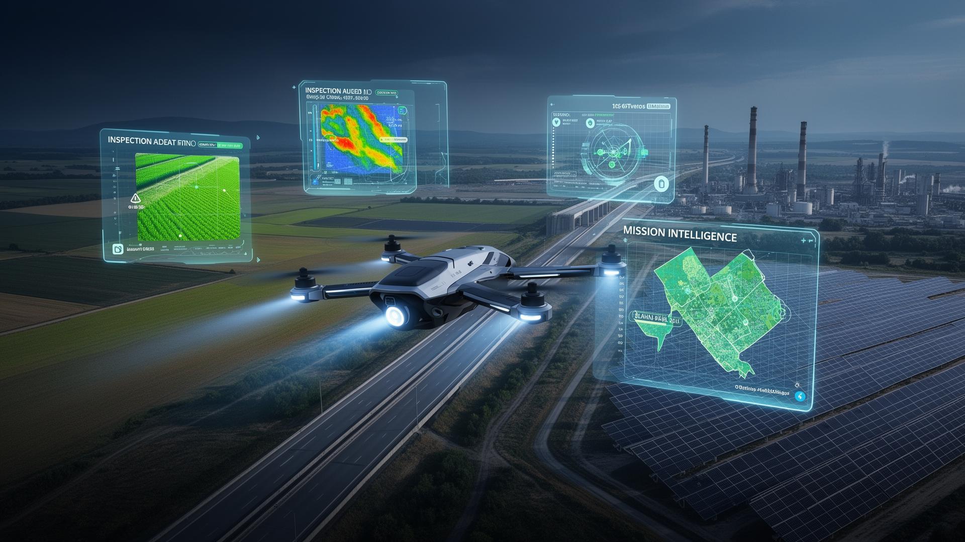
Drones, data, and intelligence in one platform
AeroSpawn combines aerospace engineering, custom UAV systems, aerial imaging, AI analytics, and domain-specific workflows to convert drone missions into actionable business intelligence.
Custom drone systems
Purpose-built UAVs engineered for specific industry missions.
AI-powered aerial analytics
Computer vision models that turn imagery into decisions.
Industry-specific verticals
Tailored workflows for agriculture, infra, mapping and more.
Mission planning & reporting
From flight plan to PDF — operations end-to-end.
Scalable drone operations
Repeatable processes from a single farm to enterprise fleets.
Research & prototyping
Rapid prototyping of payloads and aerospace experiments.
Built for multiple industries
Six focused service lines, one unified aerospace and AI platform underneath.
AgriSky
Agriculture Drone Intelligence
Drone-based farm monitoring, crop health analysis, irrigation insights, organic farming advisory, and future precision spraying support.
Explore AgriSkyInfraSky
Infrastructure Inspection
Drone-based inspection for roads, bridges, buildings, telecom towers, solar farms, and industrial assets.
GeoSky
Mapping & Survey Intelligence
Aerial mapping, land survey, site progress monitoring, GIS data capture, and terrain intelligence.
GuardSky
Aerial Surveillance & Early Fire Response
Drone-based real-time monitoring, smoke/fire detection support, live aerial visibility, rapid alerts, and targeted first-response payload deployment for farms, industrial sites, campuses, remote facilities, and critical assets.
Explore GuardSkyAeroSpawn Labs
Custom UAV R&D
Custom drone design, payload integration, flight testing, aerospace research, and prototype development for specialized use cases.
AeroSpawn Academy
Drone Pilot Training & Certification Support
Practical drone pilot training, safety procedures, mission planning, agri-drone operations, mapping workflows, and certification support for students, farmers, drone operators, SHGs, FPOs, and professionals.
Explore AeroSpawn AcademyOne platform. Many missions.
Every vertical shares the same modular UAV, data, and AI stack — engineered once, deployed everywhere.
Flagship vertical: AgriSky
Agriculture drone intelligence by AeroSpawn
AgriSky helps farmers and agri-organizations monitor crop health, detect stress early, plan irrigation, and enable precision farming using drone imagery and AI-based farm advisory.
Explore AgriSkyDrone-based farm monitoring
Crop health & stress detection
Farm zone mapping
Irrigation & organic input advisory
Farmer-friendly reports
Future precision spraying support
GuardSky
Aerial surveillance and early fire response by AeroSpawn
GuardSky is a prototype drone-based surveillance and emergency-support solution designed to monitor critical areas, detect possible fire or smoke incidents, provide real-time aerial visibility, alert operators, and support rapid intervention through targeted deployment of fire suppression payloads near the incident zone.
Explore GuardSkyReal-time aerial surveillance
Smoke and fire detection support
Live monitoring and alerting
Rapid first-response support
Payload deployment prototype
Remote area and asset monitoring
Use cases
Industrial sites
Warehouses
Solar farms
Farms and rural land
Campuses and institutions
Remote infrastructure
Resorts and retreat properties
A modular aerial intelligence stack
AeroSpawn's technology is built as a reusable platform that powers multiple industries — from a single mission to enterprise-grade aerial operations.
Drone Mission
Custom UAV or partner drone captures aerial data.
Data Capture
RGB, thermal, multispectral, LiDAR, or sensor-based data.
AI Analysis
Vision models detect patterns, risks, defects, stress, and changes.
Actionable Reports
Dashboards, PDF reports, alerts and recommendations.
Operational Intelligence
Insights for inspection, advisory, planning and automation.
What AeroSpawn builds
Custom UAV Design
Payload Integration
Drone Mission Planning
AI Image Analysis
Aerial Mapping
Crop Intelligence
Infrastructure Inspection
Surveillance Workflows
Reporting Dashboards
Drone Service Operations
Pilot programs and partnerships
AeroSpawn is building pilot programs with agriculture farms, infrastructure owners, drone operators, academic institutions, FPOs, and industry partners.
AgriSky Farm Pilot
Drone imagery and AI-based crop health reports for farms.
Apply for pilotInfraSky Inspection Pilot
Drone-based inspection and reporting for infrastructure and industrial assets.
Apply for pilotCustom UAV R&D Pilot
Prototype development and payload testing for specialized aerospace use cases.
Apply for pilotBuilt by aerospace and software engineering minds
AeroSpawn brings together aerospace engineers, software engineering, AI, drone systems, and field-domain expertise to build practical aerial intelligence solutions for real-world industries.
Aerospace engineering
UAV design
Flight systems
AI & software platforms
Field pilots
Industry partnerships
Training the next generation of drone pilots and aerial intelligence professionals
AeroSpawn Academy provides hands-on drone pilot training and certification support for students, farmers, rural entrepreneurs, SHGs, FPOs, and professionals. The program focuses on safe drone operations, mission planning, field applications, agri-drone workflows, mapping basics, maintenance awareness, and real-world drone service readiness.
Drone Pilot Training
Learn drone basics, flight safety, controls, emergency handling, and field operations.
Agri-Drone Operations
Learn drone usage for farm monitoring, crop imaging, spraying workflows, and precision agriculture services.
Mapping & Survey Training
Learn aerial mapping basics, mission planning, data capture, and reporting workflows.
Drone Maintenance Basics
Understand batteries, propellers, motors, payloads, pre-flight checks, and post-flight maintenance.
Certification Support
Guidance and preparation support for drone pilot licensing and certification pathways through authorized channels.
Career & Entrepreneurship Pathway
Support for students, operators, SHGs, FPOs, and rural entrepreneurs to start drone-based service businesses.
Partner with AeroSpawn
Whether you are a farmer, infrastructure company, drone operator, investor, institution, or industry partner — AeroSpawn is open to pilots, partnerships, and custom drone intelligence projects.
- Gouthaman — +91 99402 63589
- hello@aerospawn.in
- India